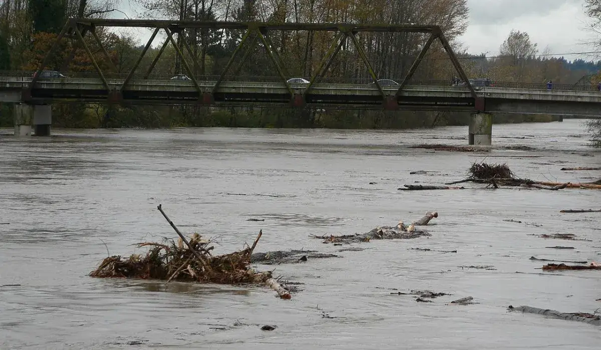
The Snohomish River is now forecast to surge past all known measurements this week, driven by a powerful atmospheric river drenching Western Washington.
Forecasters with the National Weather Service in Seattle said the river will rise quickly after falling below flood stage Tuesday night, Dec. 9, returning to major flood levels Wednesday.
The water level at downtown Snohomish is expected to peak at 34.6 feet around midday Thursday. The previous record — 33.5 feet — was set during the historic 1990 floods.
The Northwest River Forecast Center (NWRFC) issued a statement saying, “Flood waters will likely overtop levees…with major levee damage possible. Flood waters will inundate much of the river valley…including SR2 west of Monroe…SR9 and the Lowell-Snohomish River Rd.”
Flooding was expected to occur all along the river including headwaters, tributaries, and other streams within and near the Snohomish River Basin. A stage of 33 feet on the Snohomish River corresponds to a Phase 4 in the Snohomish County flood program.
A Major Atmospheric River Is Fueling the Surge
The “Pineapple Express”–style system pulled into the region Monday, delivering two waves of warm, subtropical moisture capable of dropping several inches of rain across the lowlands and up to 10 inches in the Cascades through Wednesday night. Snow levels are expected to rise to around 7,000 feet, meaning rain — not snow — will pound the mountain passes, accelerating runoff into local rivers.
The combination of heavy lowland rain, mountain rain, and snowmelt is expected to push several waterways into moderate or major flooding through late week, according to the National Weather Service.
Snohomish: Major Flooding Expected Near Snohomish and Monroe
At 7:56 p.m. Monday, the river gauge near Snohomish measured 18.2 feet — still within normal conditions — with flood stage marked at 25 feet.
“At 32 feet, the Snohomish River will cause major flooding,” the warning stated, noting overtopping near French Slough and potential breaches at several levees. Lowlands, farm fields, and multiple roads are expected to flood.
Near Monroe, levels are expected to crest near 18.8 feet Tuesday afternoon, pushing the area into major flooding.
While the Snohomish River is predicted to dip back below flood stage briefly on Tuesday evening, the break will be short-lived. The second wave of the atmospheric river arrives late Tuesday night, and forecasters expect the river near Monroe to rise again early Wednesday, climbing back into major flood stage by mid-morning.
At major flood levels, low-lying farmland, rural roads, and access routes near the Skykomish-Snoqualmie confluence typically see widespread inundation. Some isolated residential areas in the valley may also become difficult to reach as floodwaters expand across the basin.
Stillaguamish River: Moderate to Major Flooding Expected
The National Weather Service also issued a flood warning for the Stillaguamish River near Arlington, where gauges read 11.8 feet Monday night. Flood stage is 14 feet.
The river is projected to spike to 17.8 feet early Tuesday, approaching levels not seen since November 2003. Flooding is expected along Norman Road, Silvana, and Florence. After briefly dropping Tuesday night, forecasters say the Stilly will rise again and crest near 15 feet Thursday.
Historic Context: 1990 Floods Still Set the Benchmark
The forecast surpasses levels recorded during the devastating November 1990 floods — the worst in Snohomish County history. That event, fueled by persistent rain on saturated ground and deep mountain snowpack, caused widespread destruction:
• Multiple levee failures and overtopping
• Serious damage to farms, homes, and county roads
• Hundreds of cattle lost
• National Guard deployment and widespread evacuations
The disaster reshaped local flood response and led to improved dike designs, home buyouts, and elevations in vulnerable neighborhoods.
Landslide Risk Rising Across Western Washington
The National Weather Service warns that saturated soils combined with continued heavy rainfall will significantly increase the risk of landslides and debris flows through midweek. Steep coastal bluffs, hillsides, road cuts, and burn areas face heightened danger. The threat may linger for days even after the rain stops.
County Tools and Resources
- Snohomish County Emergency Management urges residents to use its Public Safety Hub, which offers real-time river gauges, interactive maps, alert sign-ups, and updates during active flood emergencies.
- Link to river forecasts
- Link to current flood warnings
Want more local news? Follow Puget Press Everett & Puget Press Snohomish County on Facebook.